Tuesday, 31 May 2011

ROCK CLIMBING - BOX BAY (May 2011)


. South Wales Mountaineering Club - Box Bay
Box Bay, Porthcawl is about 500 – 600 metres south east along the coast path from Rest Bay (car park), it has excellent solid rock for the majority, but a little looser on the right towards the overhangs.

Climb approx 4 hours either side of low tide. The rock dries very quickly and is a lovely warm suntrap, but can be windy at the top.

The use of old or older rock shoes is recommend as the rock is very sharp and destroys the soles, its aspect makes it an excellent area for SPA training and/or assessment, great for beginners.

Wednesday, 20 April 2011

MOUNTAINS OF MADEIRA (April 2011)


Madeira is 400 km north of Tenerife, Canary Islands, in the north Atlantic Ocean and an outermost region of the European Union.[4] The archipelago comprises one of the two Autonomous regions of Portugal (the other being the Azores located to the northwest), that includes the islands of Madeira, Porto Santo, the Desertas and the Savage Islands.


Madeira was re-discovered by Portuguese sailors in the service of Infante D. Henrique (Henry the Navigator) in 1419, and settled after 1420. The archipelago is considered to be the first territorial discovery of the exploratory period of the Portuguese Age of Discovery.


The island of Madeira is at the top of a massive shield volcano that rises about 6 km (3.7 mi) from the floor of the Atlantic Ocean, on the Tore underwater mountain range. The volcano formed atop an east-west rift in the oceanic crust along the African Plate, beginning during the Miocene epoch over 5 million years ago, continuing into the Pleistocene until about 700,000 years ago.


It has a mountain ridge that extends along the center of the island, reaching 1862 metres (6,107 ft) at its highest point (Pico Ruivo). The primitive volcanic foci responsible for the central mountainous area, consisted of the peaks: Ruivo (1862 metre), Torres (1851 metre), Areeiro (1818 metre), Cidrão (1802 metre), Cedro (1759 metre), Casado (1725 metre), Grande (1657 metre), Ferreiro (1582 metre).


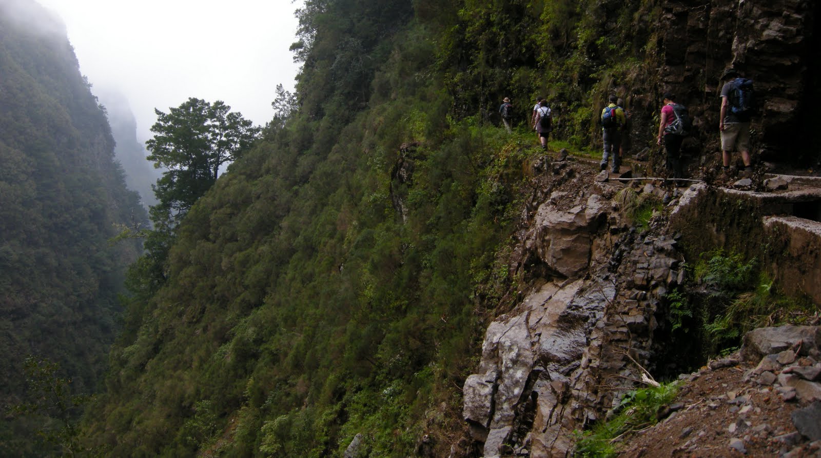
There are over 1,350 miles (2,170 km) of levadas and they provide a remarkable network of walking paths. Some provide easy and relaxing walks through beautiful countryside, but others are narrow, crumbling ledges where a slip could result in serious injury or death.


Two of the most popular levadas to hike are the Levada do Caldeirão Verde and the Levada do Caldeirão do Inferno which should not be attempted by hikers prone to vertigo or without torches and helmets. The Levada do Caniçal is a much easier walk, running 7.1 miles (11.4 km) from Maroços to the Caniçal Tunnel. It is known as the mimosa levada because mimosa trees are found all along the route.

Wednesday, 17 February 2010

ROCK CLIMBING IN MALAGA (Feb 2010)


Spent a week Rock Climbing in the area behind Villanueva del Rosario on El Corral, Los Pinos and Taco del Madera with a couple of climbs on Villanueva del Cauche.

Weather was great and quite warm, some Trad climbing, but also first introduction to Sport Climbing which I really enjoyed, it was good fun.

Excellent instruction and guidance by "The Rock Climbing Company", it offers adventurous mountain activities in Snowdonia and Spain. The company and courses are run by climbing instructor Silvia Fitzpatrick and they are supported by Simon Marsh.

Silvia Fitzpatrick is a Mountaineering and Climbing Instructor who has been climbing all over the world at a high level for more than 22 years. Simon is SPA qualified and head of climbing at DMM. He is also a director of the Ground Up which researches and publishes rock climbing guidebooks. For more infomation; Contact Silvia at http://www.rockclimbingcompany.co.uk/

Villanueva del Rosario is a small town off the motorway from Málaga to Granada and Seville.
The white washed pueblo sits at the base of the Cerro de la Cruz, with rolling countryside on the other three sides. Famous for the quality of its olive oil.

Wednesday, 20 January 2010

WINTER IN WALES (JAN 2010)


The Black Mountains (Welsh Y Mynyddoedd Duon) are a group of hills spread across parts of Powys and Monmouthshire in southeast Wales.


They are the easternmost of the four ranges of hills that comprise the Brecon Beacons National Park, and are frequently confused with the westernmost, which is known as the Black Mountain . To confuse matters there is a peak in the Black Mountains called Black Mountain.


The Black Mountains may be roughly defined as those hills contained within a triangle defined by the towns of Abergavenny in the southeast, Hay-on-Wye in the north and the village of Llangors in the west. Another 'gateway' town to the Black Mountains is Talgarth

Wednesday, 7 October 2009

WALKING IN CRETE (October 2009)


Crete (Greek: Κρήτη, is the largest of the Greek islands and the fifth largest island in the Mediterranean Sea at 8,336 km² (3,219 square miles). Crete is one of the 13 peripheries of Greece and covers the same area as the Greek region of Crete from before the 1987 administrative reform It forms a significant part of the economy and cultural heritage of Greece; while it retains its own local cultural traits (such as its own music and dialect), Cretans identify themselves as Greeks. Heraklion is the largest city and capital of Crete.
Crete was the centre of the Minoan civilization (circa 2600–1400 BC), the oldest Greek civilization. The island is the location of significant ancient history, which provides popular modern day tourist destinations. They include the Minoan sites of Knossos and Phaistos, the classical site of Gortys, the Venetian old city and port of Chania, the Venetian castle at Rethymno and the Samaria Gorge.
Crete was the centre of Europe's most ancient civilisation; the Minoan. Early Cretan history is replete with legends such as those of King Minos, Theseus, Minotaur, Daedalus and Icarus passed on orally via poets such as Homer.

Friday, 7 August 2009

HIGH IN THE DOLOMITES


The Dolomites (Italian: Dolomiti; German: Dolomiten; Friulian: Dolomitis) are a section of the Alps. They are located for the most part in the province of Belluno, the rest in the provinces of Bolzano-Bozen and Trento (all in north-eastern Italy). Conventionally they extend from the Adige river in the west to the Piave valley (Pieve di Cadore) in the east.

The northern and southern borders are defined by the Puster Valley and the Sugana Valley (Val Sugana). But the Dolomites spread also over the Piave river (Dolomiti d'Oltrepiave) to the east; and far away over the Adige river to the west is the Brenta Group (Western Dolomites); there is also another smaller group called Piccole Dolomiti (Small Dolomites) located between the Provinces of Trento and Vicenza .

During the First World War, the line between the Italian and Austro-Hungarian forces ran through the Dolomites. There are now open-air war museums at Cinque Torri (Five Towers) and Mount Lagazuoi. Many people visit the Dolomites to climb the Vie ferrate, protected paths created during the First World War. A number of long distance footpaths run across the Dolomites, which are called "Alte via" (i.e., high paths).

Such long trails, which are numbered and are served by numerous "Rifugi" (huts). The most renowned are the Alta Via 1 and Alta Via 2

Alta Via 1 s a 150 km long high level path which runs through the eastern Dolomites in Italy. Alta Via 2 is 185 km long high level path which runs through the western side. They known as the Dolomite High Routes and passes through some of the finest scenery in the Dolomites.

About 10-15 days are required to complete the full routes. A typical day on the route might involve about seven hours walking, with ascents and descents of about 1,000 metres and can be attempted during the period July to September, when the route should be largely free of snow.